2012-2018- Andalucia- Capistrano Village, Nerja and Hikes
The below map orients Nerja on the southern coast of Andalucia, Spain. We fly into Malaga and head 50 kms. east to Nerja.
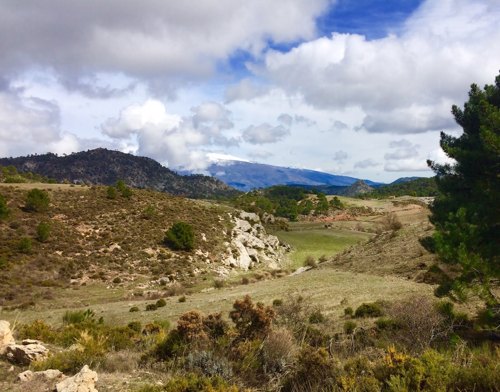
This shows Nerja on the Mediterranean Sea with the Sierra beyond the Capistrano Village where we have stayed the last 5 years. The mountains have many hiking trails heading up the gullies and to the summits.
CAPISTRANO VILLAGE AND NERJA
Via Romana shown above goes through the center part of Capistrano Village. This is the original road of the created village and is located on the old Roman Road from 2000 years ago! Capistrano Village was developed in the late 1970's and is intended to represent an Andalusian White Village or peublo. The people who funded it are from Montreal and they used money from their profits for Trivial Pursuit! They bought a whole olive grove near Nerja and then developed it, winning an architectural award.
A major feature of Capistrano Village are the outstanding landscaping, with gorgeous flowers and blossoming fruit trees. A few examples: above the jasmine flowers are in bloom around early March. What a wonderful scent!
This is the view to El Cielo mountain range at sunset, seen from our apartment's front door and our bedroom window.
Below, friends wave to me from our apartment terrace.
Morning sunrise view from the terrace....I do my meditation and stretches right here!
Cheers!! Every evening we watch the sun go down while enjoying dinner out on the terrace.
Looking back to our apartment on the upper left. That is Robert in the pool!
The Capistrano Village Social Salon is absolutely one of the biggest reasons we come back, year after year. It has been brilliantly developed over the last 40 years and brings together this very special community of people multiple times a week over 6 months. Mondays: Movie night with a glass of wine, Tuesdays: French conversation, Thursdays, the lecture series (flora and fauna of Spain, the Franco years, excursions to nearby villages, and other historical presentations). In Nerja's Old Town at the Historical Society, there are many more presentations throughout the season. Friday Music Nights with a glass of wine, Saturday morning the library, Fridays: Spanish conversation, Saturday evening once a month, a themed dinner. Here are Robert and I in 2015 when we presented a Canadian dinner! Cornbread and Bannock with seafood chowder, Maple-Glazed chicken with root vegetables, strawberry shortcake with maple sauce.
A fun night last season was ladies night....put on by the special ladies with our wonderful MC, Colin. Here is our entree with melon and prosciutto, with wine flowing all night.
NERJA AREA
Above shows Ayo's "all you can eat" paella restaurant located on Burriana beach. This is a 20 minute walk from our apartment. The fellow stirring up the rice is one of the people who discovered the Cueva Nerja in 1978. Below pictures show the various beaches, 4 in all, that line the Nerja coastline.
Relaxing with the waves....
Lovely view from Burriana Beach, with Cielo mountain range beyond.
Sue with Nerja cup in hand.
Burriana beach shops
View from Torrecilinas beach on the west end of Nerja. Cielo mountains beyond.
Cueva Nerja is being nominated for a UNESCO designation. It is actually located in Maro.
Stunning view eastwards from the Balcon Europa along the coastline with such an interesting cloud formation! Yes, that is the Cielo mountain range.
Above, Balcon Europa bronze statue and a great view to Capistrano Village and the Cielo mountain range.
Below, Mercadona superstore sausage and jamon display!
Sue on Burriana Beach. The cliffs of Maro and beyond where we do our coastal hikes.
Capistrano Village has just stunning flowering bushes and landscaping.
FRIGILIANA VILLAGE NEAR NERJA
For one euro, you can take a bus and go up to Frigilaina, 4 kms. into the mountains.
Restaurants and shops are found in this very pretty mountain village.
What a meal with Gary and Rosa!! Above, the 3 tower veggie meal: goat cheese, eggplant and tomato with honey sauce.
Above is a great view of Frigiliana Village looking up the Hugeron River. Fuerte mountain is to the left. See below map to orient yourself. Another nice view from Frigiliana.....the cerveza is always welcome after a good hike!
A very typical Spanish lunch, thank you, Jane!
Here is a good overview of the hikes we have done in the immediate area of Nerja.
The below map shows the contours of these mountains.
Very safe walking and hiking in southern Europe EXCEPT for these nasties: processional caterpillars. BEWARE!!!
They hatch out of huge nests in early March that hang from pine trees, "process" down to the ground by the tree trunk and seek a nest in the ground. Some of their processional "trains" are 10-30 feet long. There is a very dangerous toxin on the tips of their fur which causes welts and blistering. An animal's throat could swell up and close if they get this in their system. so be careful if you have a pet.
Humans "just" get nasty blisters. People have been blinded if the toxin gets smeared into their eyes. One climbed on to my knapsack and, until I figured out that I needed to launder my knapsack to remove all the toxins, I kept developing these bad welts.
Wild boar could be dangerous but they are nocturnal. You will see evidence of their rooting about underneath trees to get at the bulbs and fungii.
Caminita del Rey
To get a really neat perspective of the Caminita del Rey BEFORE the repair work have a look at this video which gave me vertigo!
https://www.youtube.com/watch?v=fcczjFRcVcU
Here's a Wikipedia history of this amazing trail...
https://en.wikipedia.org/wiki/Caminito_del_Rey
Orientation session with our guide....
Hard hats mandatory and we signed a waiver form as well.....the tickets below were organized by friends Lorraine and Bill who had done it already and were keen to do it again with us!
Entering the first gorge, narrow and exciting. Lorraine seen on walkway with her hard hat on.
Looking back towards the first gorge.
Old waterways and sluices of the hydro project from 100 years ago, seen below us. Remnants of the waterworks were seen throughout the walk.
Above, view of the old bridge which connected the walkway to the railway line. Robert, Lorraine and Bill are looking back to me.
Below, a view of the crumbling 115 year-old construction (started in 1901 and finished by 1905) with new boardwalk above- stainless steel and pressure-treated wood.
Robert is on the walkway with the incredible karst geology rising behind him.
Be careful where you step! One of the many obvious reasons they closed the old walkway down and did a complete renovation over 2 years.
View from entrance to 2nd gorge looking back over valley to 1st gorge
Walkway to connect from the valley to the 2nd gorge
Incredible wind erosion on cliff face shown above
Old walkway over the water pipe (can be seen in the YouTube video) with the new stainless steel suspension walkway to the right....which bounced as we walked it. Only 4 people at a time could traverse this suspension bridge. Several tourists needed to be helped across.
Old resistor from hydro-electric project along cliff face with bridge beyond
Many people died trying to walk the old Caminta del Rey. Here is a plaque to 3 people who died at the same time, trying to zip-line over the gorge.
"Ants" on the wall after exiting the 2nd gorge .
Train tunnel and bridge seen at end of our trek, still in use to this day. We saw several trains bombing along while traversing the inner valley.
Only "death" was spotting someone's dropped blue iPad seen 1000 feet below!!
We plan to return in 2018....love this hike! Anybody interested??
EL FUERTE HIKE- 7 kms. round trip
The summit of El Fuerte can be seen at the top left and is 3.5 kms. from the uppermost part of the Frigiliana village. Scrambly at times, it is generally a good track with views to the northern Sierra (seen in below picture)
Video looking towards the sea from the summit of El Fuerte:
Here is the view from the summit of El Fuerte back to Frigiliana and to the Mediterranean Sea.Way beyond on the coast is Nerja.
Video looking north from the ridge of El Fuerte
Hiking down from the summit of El Fuerte with the trail seen along the below ridge. Stopping at Peter and Claire's spa paradise....lovely people who helped out during a hiking mishap. View from their terrace with Cielo beyond.
A short walk into Frigiliana and there is a wonderful terrace which overlooks to the mountains and to the Mediterranean Sea. Cheers!
We can walk out from our apartment and through the Capistrano Village, reach the trailhead of Canada and head up. A nice way to spend a half-day....and there is KK's Bar at the bottom to enjoy a cold beer. Excellent Balti Indian food in this friendly British-style pub, prepared by Kim, hosted by Kerry who always remembers our favorite cerveza! Above- Looking east down the coast towards Maro. Below- View from top of Canada hike down to the Capistrano Village at the base with Nerja beyond.
Climbing up the Cierro hike from the village.
View from the Cierro hike with El Cielo beyond (top) and north to the Sierra mountains (below)
Video from the top section of the Cierro hike looking north:
At the top of the Canada hike, there is a great add-on trail which heads westward towards the rio Chillar ravine. Here we are heading into the up and down area of this trail....
At the top of the Canada hike....Capistrano Village below.
Fabulous views over to Frigiliana and the rio Chillar ravine, Robert making his way down the slope.
Pause that refreshes....
The Japanese garden section, as named by Lorraine.
Views of some of the natural caves which overlook the rio Chillar.
Picnic time overlooking the rio Chillar...Lorraine and Bill enjoying the view to the riverbed after descending from the cliff top..
EL CIELO via ROMERO route- 10 kms. round trip
Looking back down the winding track bringing us to the top of Romero.
Above is the view to the Miel Valley and Almenjar before the final ridge walk up to the summit of El Cielo, seen beyond Sue in the below picture. Later in the Blog there is a description of the hike up to overlook of the Miel |Valley, seen at lower left. You can see Herradura beyond the furthest ridge. Here I am with Rose and Ann last year at the turn to go up to the top ridge.
Gusting wildly at the summit, above. Then a bit of clearing for a spectacular view back to Nerja and the coast, below. The caves of Maro can be seen at the below left which is where we start our hike up the valley. Romero is halfway up to this summit. Below, view from the trail.
Our friends' family in 2017 above....and me in 2015
Heading down from El Cielo, with the hiking trail seen below. Then a well-deserved break from this trek on Romero.
ACEBUCHAL HIKE- 7 kms. loop
On our way to Acebuchal, you have fine views to the village below.
To the left, out of the picture, is Lower Acebuchal and it is on the
walking route to Competa. Beyond, is the Puerto Blanca.
Fascinating village which has been brought from the ruins of Franco's civil war years. Various people have invested in the reconstruction of it and every year we go to see the new developments. Above, the bar/restaurant which is the gathering point for hiking groups. Below one of the side streets, so pretty.
Our happy group of hikers, Richard, Bill and Lorraine, starting out at the Acebuchal village. On the horizon you can see the Puerto Blanco which is our destination (below picture with Robert and Bill). Lucero can be seen on the horizon. The rio Hugeron which starts near Nerja is way below in the valley. There is a description of the Hugeron river hike below.
Looking out from an abandoned inn that sheltered trekkers in past years.
Fascinating plant called....
The village of Acebuchal is very welcoming....had a nice beer and tapis as we shared stories about our hike. Here is an assortment of excellent local craft beer.
Below, Rosa and I in front of the first building to be reconstructed, the church....in 2007.
On the way to Competa with Lois, Richard, Jim and Diane
An anti-clime geological formation....lunch below.
RIO CHILLAR RIVER WALK to LA PRESA-2014- 8 kms. round trip Starting right at the Capistrano Village, we walk up the rio Chillar for 4 kms. to La Presa. At 2 kms, there is a small hydro-electric plant which processes electricity for Frigiliana. There is a huge pipe there which provides much water coming from a mountain top spring. At the 3 kms. mark the river walk intersects with the Lamon trail (see below, goes from Frigiliana to Fuente Esparto. The rio Chillar is relatively dry though there are sections with quite a bit of water especially after a day's rain, needing hopping from rock to rock. Bring poles and your water shoes as you'll need to criss-cross the river many times!
SIERRA NEVADA Cerro el Calar HIKE-2015- east ofGranada- 10 kms. round trip Below is the view back to Guejar Sierra village and the reservoir where we started the hike after driving from Granada. We did a 6 km loop as we had to head back to Granada to pick up our friends who were touring El Alhambra while we hiked.
Warm day, lots of snow but melting fast....beyond is the ski hills of the Sierra Nevada.
Looking back to the "saddle" we hiked up to from the village.
Remnants of trenches and protections from the civil war in the 1970's between Franco and his opposition.
On our way down, foundations from long-ago farms.
Joined up with friends Gail and Bob after their tour of Granada, then drove up the twisty road to the Sierra Nevada ski area....
Crux d'El Pinto Hike- from Nerja to the summit- 3 kms. one way
Frigiliana "white village" view. El Fuerte hike is beyond the "white village" and the Lamon Trail towards the Fuente Esparto angles off to the right.
At the Cruz (Cross) of the Pinto with Penny and Robin- Nerja village and the coast beyond.
Video from summit of Cruz del Pinto:
MARO HIKES
The sugar mill of Maro which was part of the ----family's monopoly on sugar making.
View down the coast from Maro with one of the watch-towers seen.
View to El Cielo from Maro Road
On the trail towards the Torre Maro passing by the sugar mill.
Stunning view eastwards from the Torre Maro
Hike up from Playa Alberquillas(east of Maro) to overlooking the rio Miel-2015
Halfway up the riverbed trail we enjoy the Arched Bridge....
Picnic time at the overlook with the ridge to El Cielo beyond....
Below is a beautiful view east, with the Miel Valley below and the coastline towards Almenjar.
Video overlooking the Miel Valley
New road construction crew....!
EL TORCAL Hikes near ANTEQUERA- multiple visits
Called the Enchanted Mountain, El Torcal has 3 loop hikes which take you through this twisted and fascinating landscape. The longest loop is about 5 kms.
Looking south from the ridge is the village of El Concepcion, which is one of the major entry points for the nature park. The other entry point is from Antequera to the north. There is a full-sized Visitor's Center, complete with theater to view an excellent introductory movie, restaurant and gift shop.
The Mediterranean Sea can be seen beyond, with Malaga and the airport behind the furthest ridge. The Tour Andalucia cycling competition has come up and around this ridge as one of their "queen" stages. Vamos Valverde!
Friends Maria and Andreas who came to visit from Austria enjoyed walking the longest loop with us, taking several hours. Wear boots and bring poles as there are some tricky sections to this hike.
The fickle finger of fate pointing skyward....
2017- JIM AND DIANE WITH LOIS
2018- With Jim and Diane, Karl and Liz
Hugeron River and Canyon Hikes
This is a fascinating, excellent hike up to Frigiliana. It is about 5 kms. from Capistrano Village. The first 3 kms are in a dry wide river bed which narrows dramatically as can be seen above and below.
This hike involves hopping from one side of the river to the other, best not done after a day of heavy rain. Water shoes and poles will help!
At one point, because of a rock collapse, a cement stairway has been fashioned with NO handrails. I kept low and "crawled" up. Penny was a brave trooper!
The last section of this hike is very scrambly and needs careful navigation of brambles and water dams. Suddenly, you are out in the open and the steep road up to Frigiliana is to your left. The below map shows some of the Cruz de Pinto hike, the Lamon hike and the Hugeron riverbed hike . Though not marked, the Hugeron river south of Frigiliana is the canyon hike. It also shows the relationship between the rio Chillar and rio Hugeron which splits just north of the A-7 autovia.
View towards Cruz del Pinto and the Hugeron River trails
2017 with Lois up the Hugeron Canyon-
Another excellent hike is starting in Frigiliana, descend to the Hugeron Riverand head north on the river bed with Lucero in sight for most of the hike. 4 kms. there and back
Picnic stop with great views to Lucero
Amazing stone formations along the way....
Hiking buddies Penny and Robin in 2016
Montejaque to Ronda Hike- 10 kms. there and back
Looking eastward over Montejaque towards "saddle" leading to Ronda
Views of Montejaque from overlook, looking westward....our apartment is at middle-left. No cars allowed! Grazalema Park is beyond this ridge.
Once a major commerce route between Montejaque to Ronda, it has become a great hiking trail. Beautifully patterned cobblestones give us a good grip as we ascend steeply. At the top there is a church and picnic area for the local people ( and hikers!) who celebrate their festivals here.
After hiking up and over the "saddle", Ronda can be seen across the rolling valley, always beckoning us onward.
Looking back towards the ridge we climbed over, with the cut-through ("saddle") we came through seen to the left of the high point. Montejaque is just beyond.
Nice sign boards along the way for flora and fauna.
Hiking up past the Ronda escarpment and looking back to the ridge near Montejaque.
Quite the bridge over the rio Ronda....where many people have been thrown off for "bad behavior" during the tumultuous centuries of Spanish history. Hmmmm... Lovely ceramic map of Ronda with the "bridge of sorrows" in the center. The bull ring is to the left. There are ancient Arab baths just north of the bridge area. Really, a lovely village to spend a few days in.
Back at Montejaque where we stayed for a week in 2013.
Zafarya Hike- 7 km. loop
Halfway up the north part of the loop with the snow-capped Sierra Nevada beyond.
At the summit....contemplating life.
Video of the Zafayria hike
Starting our descent, with the Zafarya trailhead below (car park can be seen)
Looking up to Zafayra saddle where the trail starts.
2017- VEREDAS BLANCAS- MARCHOMA HIKE WEST OF ZAFARAYA
Below, village we will go to after the hike....for a cafe con leche!! Then we'll drive up the zig-zag road and over the pass to the backside of the mountains and on to Zafayra.
At the top of Marchoma with the Zafayra plateau beyond us.
Nice drive to the village and voila! Cafe con leche!!
Looking back to Marchoma....
Loved seeing this goat herd....the bells were tinkling madly!!
L'Opera Hike- 6 km. loop
Sierra Nevada plateau and snow beyond. Lone tree on plateau area on our return to the trailhead.
PUENTE ARABE Hike- 7 km. loop
View back to Salares (below) and the Puente Arab (above)
Looking back to Salares, a typical beautiful "white village" in Andalucia.
The mighty Maroma is beyond us.
NERJA- coastal walks
Walking past the sugar factory of Nerja- owned by the same family that owns the Maro sugar factory.
Torrecilla coastal park
CIERRO HIKE- 5 kms. loop behind the Capistrano Village
Above, looking towards Cielo and the Romera trail. Below, Robert looking northwards at top of Cierro loop, with Fuente Esparto picnic area seen in valley.
Coming down eastern part of Cierro loop with views westward over to Frigiliana and El Fuerte peak.
LAMON Hike-Frigiliana to Fuente Esparto- 8 kms. then 4 kms. to the Cueva Nerja Below picture gives some perspective: the Hugeron River can be seen below with the ascent up to the ridge along the ravine. The 2 ridges beyond are on both sides of the rio Chillar. The arrow shows the ravine where the Fuente Esparto destination is found. Cielo and Albendron peaks can be seen.
Here is another view of the Lamon Trail as it angles eastward from the ascent from the Hugeron River and Frigiliana.
2018- with Rose and Ann
On last ridge of Lamon trail- looking north- 2016
Looking eastward from this last ridge....Fuente Esparto below, El Cielo beyond
FUENTE ESPARTO TO ALMENDRON TRAILHEAD
Above picture shows the whole Alemendron hike, zig-zagging up the side of the mountain. the trail loops around the summit past several old mine shafts. We will do this in 2016...ha!!!!
Venta Los Mineurs bar and hostel. Happy hikers above!
Nice limestone with familiar-looking fella in the cave!
Motril Hikes- Monachil
Suspension bridge....have fun!!
Looking mighty contented!!
2017- BARRANCO DE CANTARRIJAN TO PENON DEL FRALLE- CALETA
A favorite of ours....the views are incredible!!
Looking back to the ridge which is the other loop of the complete trail.
Lunch time....can't get better than this environment!
Watch-tower below.....
And back at the trailhead for a well-deserved snack.
And what a snack!!
ALPAJARRA EXCURSIONS- LOIS- 2017
Orgiva town square....and a snack bar!
Orgiva main street
Orgiva sign board....English on the right.
Eglisia Orgiva
Man of La Mancha!!
AND Orgiva WITH RICHARD AND JANE- 2017
HORSE RAID- 2016- ALPAJURRA
After the horse Raid, a series of races and treks through the Alpajarra, lunchtime!!
Hosted by one of the local families and funds raised go to a hospice.
Altitude 1297 meters!!
MARKET DAYS IN NERJA
HIKE UP TO CIERRO LOOK-OFF
VARIOUS HIKES NEAR NERJA
Roman road on the way to Maro....
Maro barranco walk with Richard, Penny and Robin
Special group of people....the very best hiking companions!! Robert P., Robert K., Richard, Lyn and Cookie, Penny and Robin
You can see Nerja peeking up at us, way below.
Cave ceremony? Richard, Lois and Robert going up the Maro barranco....one of our favorite hikes.
Inukshuk?
Below, the sugar mill with Cielo mountains beyond.
Mystery plants...
SOLABRENA EXCURSION WITH LOIS AND RICHARD- 2018
Most amazing display of octopus (pulpo) being smoked....ingenious!! Lovely winding streets up to the castle
Castilo de Salobrna...beautiful mountains beyond the town.
Roman-style baths inside the castle walls.
Water cisterns on the outer walls...
What views!!!!
Beautiful Moorish doors....and gorgeous interior.
Meijas- 2018- with Jim and Diane
Beautiful village scenes above....and look at the view we had from the top of the ridge! Gibraltor and the strait with Africa on the left. Simply WOW.
Ridge above Meijas....beyond is the Malaga airport!
Exploring Meijas really made me appreciate how much these Andalusian white villages have to offer. Below the original grotto church.
Fun near the Oficina Touristica Meijas....
Near L'Opera
Sensational views back to the snowy Sierra Nevada
Bill on a cistern....
Lunchtime at the cortijo...with a view back to the other cortijo!
Driving down the goat track.....scary and thrilling!!
Halfway point between Granada and Motril on the Goat Track....Meson los Prados
Some stunning hiking views you have put up here. My favorites would be the Sierra Nevada with the snow, the Playa Alberquillas with the cactus, El Torcal with the rock formations (karst?) and of course, Ronda, one of my favorite places on the planet. If I ever come visit, we have to do that hike


 PUENTE ARABE Hike- 7 km. loop


2 Comments:
Some stunning hiking views you have put up here. My favorites would be the Sierra Nevada with the snow, the Playa Alberquillas with the cactus, El Torcal with the rock formations (karst?) and of course, Ronda, one of my favorite places on the planet. If I ever come visit, we have to do that hike
B
Nice summary of your hikes. Nerja seems like a neat place, as a starting point. Thanks!
Post a Comment
<< Home