2017- BACK TO NEW ZEALAND!
Stop over in Zurich airport on a short flight from Malaga. The Matterhorn is on the horizon of this seemingly endless sea of Alps mountains.
Spotted the favorite whisky of one of my Scottish walking buddies. And anyone in the mood for a cigar??
Familiar scene below as we swooped into the Hong Kong airport. Last time I saw this was in 2006 when I flew out of Hong Kong after our year in China.
Below is Stanley Harbor where we visited a naval museum in 2006. It is located on the south coast of Hong Kong island, a nice bus ride from the main city of Hong Kong.
2 hours from Malaga to Zurich, then 11 hours to Hong from Zurich, then 11 hours to Auckland, NZ. Far too much flying time for me!! Let me outa here!!
Below, the reality of NZ, located smack-dab on the Ring of Fire, faults and volcanoes abounding. In 2005 we explored the South Island: Christchurch, Milford Sound, Dunedin, West Coast, Kaikoura, west coast as well as Mt cook and Queenstown. This visit in 2017, much of the North Island as well as Nelson, the "north of the south" island and a fast return to Christchurch.
Just loved to see this beautiful sign, welcoming me back to New Zealand.....Kia Ora,
Stayed at the Silver Oaks motel, a 20 minute ride from the Auskland airport by shuttle car. There were 2 restaurants within a 10 minute walk from this motel. Lots of Indian food....and the one I went to was so welcoming I returned there in 4 weeks time.
Bus ride from Auckland to Wellington a wonderful way to see the country-side. Quite rural with acre after acre of vine-yards and veggie gardens. Interesting water conservation techniques.
I used Intercity Bus Travels for 5 rides, paying a total of $C. 141. Travelled from Auckland to Wellington ($C. 38.), then Picton to Christchurch ($C. 30.). Judy drove me back up to Nelson, then I took busses from Nelson to the ferry in Picton ($C. 20.), then Wellington to Auckland (3 busses: Wellington to Taupo- $C.33, to Rotorua-$C14. to Auckland-$C. 26). Rented an Avis car from the Auckland Airport for 5 days: now there is a huge expense at $C. 424!! Far more than any other country I've travelled in. In Spain, we usually spend about $C.20 a day, using Hertz or Avis!!
Nice stop in Taupo halfway from Auckland to Wellington. 11 hour bus ride in total with terrific competent bus drivers who switched here. Roads are single lane for the most part and they are twisting and turning, quite challenging for anyone not used to driving on the left-hand side. Across Lake... is seen the Tongariro Mountain range to which I will return in 4 weeks.
Stunning flowers and fresh air....lovely views
Wonderful hydrangeas....
Stayed at a very good hostel in Wellington in the Cuba Street area, the Wellesley Boutique ($C. 167) very funky with many young people and treated myself to a meat pie and a fancy cafe con leche in a nearby pub. Accomodations in NZ are very pricey, even the hostels.
Took a bus with a helpful bus-driver from Cuba Street to the Wellington ferry terminal, the BlueRidge service. The competitor is the InterIslander, both costing the same. The ferry return ride was $C. 150. , a walk-on price.
Amazing ferry ride, I am so blessed not to get sea-sick! It was a wild ride once we got to the Cook Strait. I was invigorated and so excited by the movement of the ferry, very stable even for these sheep, seen below.
Below, we are clearing the Wellington harbor and heading into the Cook Strait.
After a wild ride across the strait, we tucked into the beautiful, gorgeous inlet that led to Picton, seen below. This ferry ride is a must-do...I loved it!!
Nice homes and B&B's (below) in Picton with a terrific waterfront that is well worth lingering on. I would return here and do the various hiking trails and the Queen Charlotte track which finishes in this pretty town. I stayed at the High Street hostel which was sufficient and was very easily walked to from the ferry terminal. Had a nice meal overlooking the Picton harbor. Great night life with many young people enjoying themselves!
Bus to Christchurch which needed to detour inland due to the ruined coastal highway resulting from the 2016 Kaikoura earthquake. Reality of Christchurch became apparent as the bus came into city center. Having spent much time here back in 2005, it was easy to see the ruination from the earthquakes of 2010 and 2011. Below is a the type of sign seen throughout Christchurch: "back here soon". The beautiful cathedral was behind tall fences as it was badly damaged.
Hazard areas were everywhere as various levels of insurance companies work out how to repair the damaged buildings. There were many "parking lots" which were the site of buildings which were beyond repair and had been torn down.
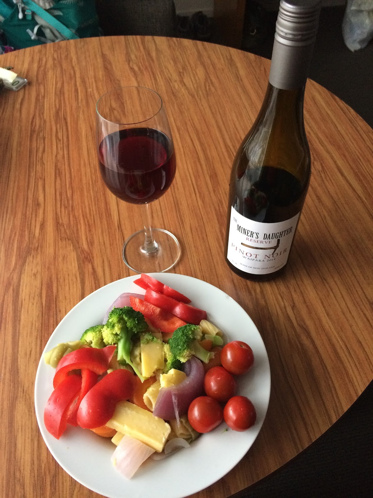
I was in Christchurch for a family wedding and stayed at Colonial Inn near the venue. 3 nights for $C.450. I was able to walk to a grocery store and had a small kitchen in the room from which I prepared some simple meals. Nice choice of truffles, wines and beers!
After the wedding festivities, we toured around Christchurch, ascending into the Porthills. Behind me is Littleton, the major port for Christchurch.
Lovely flowers peeking out from the interesting rocks.
Familiar view from the Porthills, looking to the Brighton Beach area. Looks very peaceful after the chaos of 2010 and 2011. The epicenter of the earthquakes were near this location.
The coastal route from Christchurch to Littleton has been closed due to damage and fear of rockfalls.
NELSON, THE NORTH OF THE SOUTH ISLAND
Went to Cable Bay a few times, once for a picnic with friends and then later to hike from Cable Bay back over to the Boulder Bank.
I walked along the below beach and spent a lovely time with friends at the far end of the beach: picnic and swimming, couldn't be better! Fascinating history about the first cable to connect this area of the world with Europe. Over 15,000 miles from this location to London, England, completed in 1876: overland as well as ocean cables. Check out this fascinating summary. Instead of 6 months for a letter by boat, it now only took ....and cost....
Above the map of Cable Bay over to Glenduan. The Cable Bay trak can be seen following the coast.
Nelson has a fantastic Saturday Market: veg and fruit as well as artisans and buskers. A lovely place to meet up with friends and get organic goods for the week.
One Saturday, they hosted a ceilidh which included a Scottish dance demonstration.
Buskers entertained many people one Saturday, here on Main Street, Nelson.
The Nelson cathedral presided over Main Street and was beautiful to view.
One day, some friends took me out for a full day of touring. First stop, Rabbit Island and a special coffee overlooking the bay. To the left beyond the sailboats is the Nelson Bay area and open ocean.
We stopped at a whimsical tourist spot, again for another great coffee!
A very special lunch stop at Dynamite Meat Pies....what tastes and what special chuckles!
Finally, found out what these strange plants are....hops! For craft beer!! The sheep seem to like grazing there.
Headed over to Abel Tasman Bay along the coast....stunning scenery and wonderful camaraderie! Click on below to see this full panorama.
The eucalyptus trees become more apparent, used to tackle the abundance of rainfall.
Looking up the coast towards Abel Tasman Park.
The start of the Abel Tasman trak. I had planned to do this over 3 nights and 4 days but there was an infestation of wasps due to honey dripping from their trees in the park. There was a warning posted in their newspapers. Regretfully, I had to cancel due to my allergy.
My friends took me to the Resurgence walking track. beautiful walk through native forests to the headwaters.
Walked the first few kms. of the Abel Tasman trak.
Stopped at an interesting eel reserve and fed the eels! Look at the size of them!!
Of course, the cats and ducks were interested in the food we were feeding the eels!  A special bench to rest and think of very precious friends.
Above, looking back to the descent from the Cable Bay hike. Boulder Bank goes along the waterfront towards Nelson and is a natural formation created by huge waves over the years.
DUN MOUNTAIN TRAIL
Several trails lead up on to Dun mountain....lovely area in a historic landscape.
A special bench to rest and think of very precious friends.
Above, looking back to the descent from the Cable Bay hike. Boulder Bank goes along the waterfront towards Nelson and is a natural formation created by huge waves over the years.
DUN MOUNTAIN TRAIL
Several trails lead up on to Dun mountain....lovely area in a historic landscape.
Above, looking back towards Nelson and below, getting into the hills of Dun mountain. Check out the sheep!
CABLE BAY HIKE- 9.65 KMS
Rimu tree sign along the trail
Looking down towards the Boulder Bank and Nelson, seen as white buildings along the coast.
Gardening at Judy's...
Scarlet runner beans.....
Harvesting every day for "tea"....the Kiwis expression for dinner.
One of the workers chopping wood for their fireplace.
Sunsets near Nelson....
Ferry ride back, from Picton to Wellington. Much calmer!
View from Victoria Peak in Wellington.
View to Wellington harbor and where the 2 ferries come in. Bus and train stations are located near the ferry terminals, very convenient.
Overview of the TONGARIRO VOLCANO CROSSING, a UNESCO World Heritage Site.
This caught my attention!
Below, sunrise at the top of the first major ascent, at 1830 meters. You can see the trailhead way beyond, 7 kms. away. Only 13 kms to go!
Sunrise shadow
Below, view to the summit of Mt Ngauruhoe, 2287 meters. Last eruption was in 1975.
Hmmm, shall I run up the slope or down the slope??!!
LOVING this!!!
Scroll to the right to see the full pano, below. Mt Ngauruhoe (2287 meters) to the left, Mt Tongariro (1967 meters) to the right.
The only mist I encountered......quickly dissipated. Hiking up from the Mangatepopo saddle.
Like the surface of the moon?
Scroll to the right to see the whole pano....
My favorite picture of all below: Mt Ngauruhoe and its vent hole beyond the mist, the Red Crater to the left.
Looking down from Mt Tongariro to the 2 Emerald lakes as well as the Blue Lake.
Double-click on the above pano to see the details of this incredible view back up to the saddle. 100's of people....
And me!!
Looking back to the Red Crater, with a good view of the trail going across the Central Crater. Double click on this pano to get all the details.
Thermal vents coming up from the volcano mass and the Sulphur Lagoon. Lake Taupo beyond.
And did we move QUICKLY!!
I finished the 21 kms. in 7.5 hours: I was picked up by shuttle van at 5:00 am, started at 7:00 am from the . The shuttle van was waiting for me at 2:30 pm (2 other pick-up times of 3:30 and 4:30. If you miss the last shuttle, you must declare an emergency to NZ Search and Rescue and pay big $$ to get back to Taupo. AMAZING adventure!
My niece stayed at this resort:
TAMAKI MAORI VILLAGE near Rotorua
www.maoriculture.co.nz
$C. 122.00 and they pick you up at your accommodations.
It was a fantastic 5 hours!
Greetings from our Maori hosts after a very entertaining bus ride from Rotorua.
Several cultural events which were all interactive for the tourists.
Story of the arrival to NZ in 1300's from Polynesia.
Cooking our dinner in the ground.
Et voila!!!
Meat and vegies....smelled and looked so good.
Entertainment before dinner.....great songs and dancing.
And a farewell song after dinner. Kia Ora.
BAYLYS BEACH NEAR DAGARVILLE
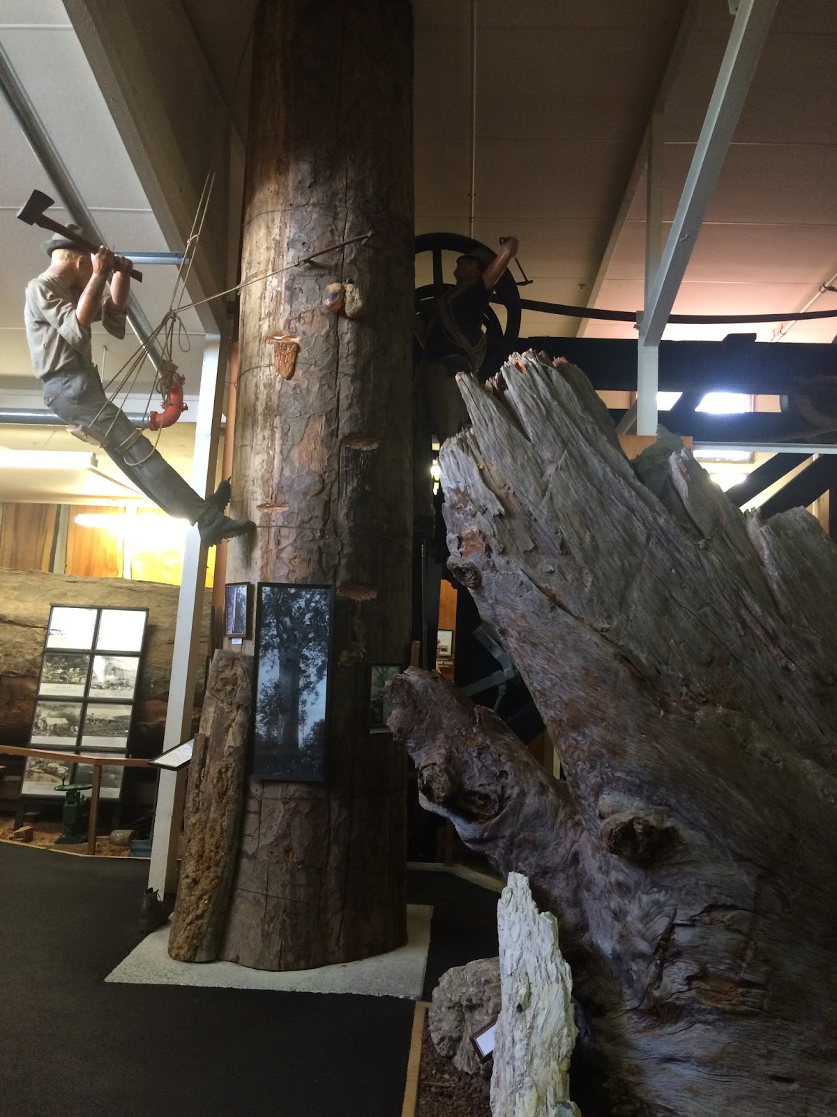
The Giant Kauri tree in Northland. 28 feet in diameter. The Kauri museum is a must-see, excellent and detailed. It is located in Matakohe, Northland.
https://www.kau.nz/
Below, Kauri gum resin, in itself a fascinating part of the kauri tree history. It has a dedicated part of the museum, quite amazed me.
There are many private collections in New Zealand and much has been donated to this museum.
Cape Reinga in the Northland- a 6 hour drive up the west coast from my beach house near Darraville.
Cape Reinga, where the Pacific and Tasman Seas meet. Scroll to the right to see the whole point. You can see the 3 Kings islands off on the horizon.
Legend and mythology.
Geology lesson.
Scroll above picture to the right to see the whole plaque.
Double click on below to see details of this pano.
HAPPY, HAPPY AM I!!
Views from my beach house balcony on Baylys Beach near Darragville. Sunsets were just stunning and truly illustrated the name of New Zealand, Land of the Long White Cloud.
Nice little kitchen for my cook-ups, views-to-die-for as I ate dinner and watched the sun going down...... and slept with the windows open to hear the nearby surf from the beach. Idyllic.
Dunes were spectacular!!
After 4 days of this little bit of paradise, back into my car rental and to the Auckland Airport....actually stayed at the same motel, the Silver Oaks Inn and enjoyed another Indian dinner at the nearby restaurant.....a 10 minute walk. the owners remembered me from 6 weeks before! The next day, on to my shuttle bus and to the airport. Below picture shows the view to the Northland and Baylys Beach and Darragvillen as I flew along the North Island's coastline.
2005- SOUTH ISLAND TOUR
BANKS PENINSULA TOUR NEAR CHRISTCHURCH
HAGLEY PARK TOURS
Beautiful flower gardens in Hagley Park, hydrangeas behind us.
ANTARCTICA CENTER, near Christchurch Airport
Expedition gear.
Experiencing a winter storm.....we got the giggles as it was very tame.
FERRYMEADE VILLAGE MUSEUM- Christchurch in the 1900 century
MAORI EVENING EXPERIENCE
Learning how to spin the ball...
The haka dance......
NEW BRIGHTON BEACH FUN
WALKS and CYCLING ALONG BRIGHTON BEACH
Christchurch Cathedral
And after the 2010 and 2011 earthquakes.
TOUR DOWN TO DUNEDIN PENINSULA
Many of these shrub fences serving as a wind-break.
DUNEDIN PENINSULA and castle
View to the Pacific ocean from the castle turrets.
Near the tip of the Dunedin Peninsula. There is an albatross colony there but we didn't go on the tour.
Next B&B?
HANMER SPRINGS
Stayed in this guest house and "took the waters" at the spa. We had mud baths, facials and massage while Robert lounged in the hot springs.
KAIKOURA EXCURSION
Ropey lava (below) along the Kaikoura coastline. We stayed in a hostel and toured. This is where the big 2016 earthquake occurred and destroyed much of the coastline and roads/ train tracks.
Hundreds of seals sunning themselves below.
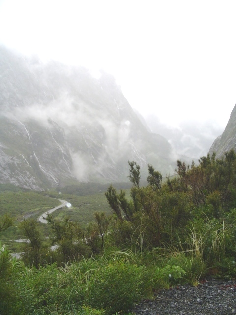
MILFORD SOUND EXCURSION
We camped at Te Anau in a campground and head to Milford Sound at sunrise. We raced the tour busses to get to the big tunnel first!
2 out of 3 days it rains on the west coast of Fiordland Park.
Start of one of the major tracks in New Zealand.
Views to the Alps.
Tour bus after tour bus coming through the tunnel....amazing engineering feat.
Waiting for the green light.
Looking down to the Milford Valley from the tunnel entrance.
Milford Sound excursion boat.....too foggy to go!
ABEL TASMAN GLACIER
MT COOK TOUR
Our little blue tent at the base of the Alps.
Walk to Mt Cook from our campground...
PORTHILLS TOUR NEAR CHRISTCHURCH
From the lookout with Brighton Beach beyond
Noah's Ark Farm
LOOKING NORTH FROM THE PORTHILLS TO BRIGHTON BEACH AND CHRISTCHURCH
QUEENSTOWN
 Incredible Mountain range.....really, that's their name!!
View down to Queenstown from the Incredible Mountain range....watched the airplanes land on the below airstrip.
Incredible Mountain range.....really, that's their name!!
View down to Queenstown from the Incredible Mountain range....watched the airplanes land on the below airstrip.
 FREIGHTER TO THE SHEEP STATION FROM QUEENSTOWN
Boarding the coal-fired steamer freighter
FREIGHTER TO THE SHEEP STATION FROM QUEENSTOWN
Boarding the coal-fired steamer freighter
Looking back to the Incredibles.....


Mechanic checking out the coal-fired engine....can you see the Aussie life-jacket??
Approaching the sheep station and looking forward to a lovely English tea-time on the veranda, met people from Montreal!
Livestock paddocks behind the farm-house....Robert over on other side, peeking at me


Sheep shearing demonstration with electric chears. What was truly impressive was the sheep dog demonstration just before the sheep shearing.....one dog separating out this sheep from a wildly milling herd of sheep.

Showing us the teeth to determine how old the sheep is....
Is this sheep happy or what?!?
2 minutes to shear this sheep, tip of the head to the toes.....all in one piece!! I liked the sheep with the sunglasses!
Last evening with views to the Incredibles
ARROWTOWN MINING TOWN
Main street Arrowtown

BUNGEE JUMPING BRIDGE
WEST COAST TOUR- ARTHUR'S PASS, GREYMOUTH, FRANZ JOSEF GLACIER AND DENNISTON
Drove from Christchurch through Arthur's Pass and Greymouth and treated ourselves to the TranzAlpine train ride coming back. Highly recommended!!
Arthur's Pass viewpoint- The Otira Gorge Road and viaduct....very impressive engineering.
Gorgeous flowers as we drove through Arthur's Pass.
FRANZ JOSEF GLACIER
Walking towards the glacier, noting the huge receding impact of its melting. Above map shows the 1867 depth of the glacier and today, 2005
Carved out bedrock above and huge boulders left behind as the glacier recedes
Torrents of water flowing from the base of the glacier with huge chunks of ice.
 At the base of the glacier, with a height of over 200 feet. This glacier is fed by the snowfields of Mt Cook, many miles to the east.
PANCAKE ROCKS near Denniston
Beware the penguin....in Israel we spotted a camel crossing warning sign!
Incredible booming sound as the waves from the Tasman Sea hit between these interesting pancake formations.
At the base of the glacier, with a height of over 200 feet. This glacier is fed by the snowfields of Mt Cook, many miles to the east.
PANCAKE ROCKS near Denniston
Beware the penguin....in Israel we spotted a camel crossing warning sign!
Incredible booming sound as the waves from the Tasman Sea hit between these interesting pancake formations.
Special dinner in Greymouth...Robert had pan-fried ostrich or was it kangaroo? I stayed conservative with the yummy minty lamb.
Special beach walk on the west coast near Greymouth as the sun started to set. Such fantastic driftwood sculptures along the beach as well as a volleyball court!
Stone-chair with stone-age man!
 Just loved the whimsical nature of these creatures!
Lovely landscaping outside our Greymouth B&B. Weird people there, though....
Just loved the whimsical nature of these creatures!
Lovely landscaping outside our Greymouth B&B. Weird people there, though....
Sooooo.....can you forgive us that we couldn't believe our eyes??!! This is the ONLY rail line connecting Greymouth with Christchurch.
Time to return to Christchurch by TranzAlpine Express...an amazing train ride through the NZ Alps. Long tunnels, massive viaducts over deep gorges and canyons. Stood out on the open deck and was thrilled!
Below, nice stop for 20 minutes at Arthur's Pass.
One of many beautiful sunsets in New Zealand.....time to return to the northern hemisphere!